|
Topographic Maps of San Diego County, CaliforniaJune 16, 2020 |
This collection contains images of USGS topographic maps of San Diego County, California, including
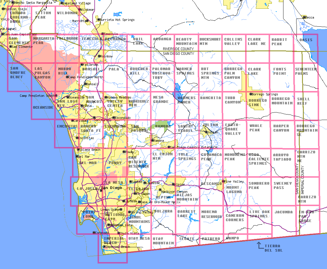
To find the desired image, look on the layout map below.
To view an image, click on the name of the map in the list at the end of this page. CAUTION: Older versions of Windows Internet Explorer won't display these images because they are too large. If you have this problem, download the image and use your favorite image software (or the Windows Picture and Fax Viewer) to view it. Or you can download the Mozilla Firefox browser from www.mozilla.com.
If your browser does clickable maps, you can also view an image by clicking on it in the layout map.
To download an image, right-click on the name and select "Save Link" or "Save Target" from the context menu.
The scale of the images is as follows:
The file LIST.TXT contains a comma-delimited list of all 7.5-minute maps. The fields in each list entry are as follows:
The latitude and longitude are those of the southeast corner of the mapped area.
The list can be imported into most spreadsheets and database management systems.
Several 7.5-minute maps have two entries each in LIST.TXT:
Each of these maps contains slightly more than the standard 7.5 minutes of latitude and longitude. The excess is an area at the edge of United States that is not large enough to merit a separate map, but it is listed in LIST.TXT as though it were a separate map with the same name.
It is quite difficult to determine the latitude and longitude of items shown on these maps. Therefore, conversion formulas for some quadrangles have been determined and posted at TOPOCONV.TXT. These formulas were derived in a manner more fully explained at topoconversion.htm. Additional quadrangles are being added to TOPOCONV.TXT as the necessary data processing is performed.
The images for this collection were downloaded in 2003 from the California Spatial Information Library.
The USGS topographic maps, the downloaded images, and the images in this collection are all in the public domain. You may use them for any legal purpose without permission or royalties. Although the maps are generally quite accurate, many of them are significantly out of date.
Philip J. Erdelsky
pje@efgh.com
7.5-minute maps:
1:250,000 maps: